


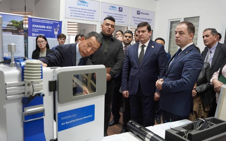
On December 10, a joint Tajik-Chinese environmental research laboratory was officially opened in Dushanbe. Located within the Institute of Water Problems, Hydropower, and Ecology of the National Academy of Sciences of Tajikistan, the laboratory is designed for environmental monitoring, water and air quality analysis, and evaluating the effectiveness of natural resource use.
Joint research and new opportunities
According to the National Academy of Sciences, the new laboratory offers unique opportunities for joint research by Tajik and Chinese scientists. The project aims to strengthen scientific cooperation between the two countries, enabling data exchange, the use of cutting-edge technologies in research, and international-level collaboration.
The equipment installed in the laboratory is a first for Tajikistan, as it is being brought into the country for the first time. Among the key devices in the laboratory are a multiparameter water quality analyzer, the portable P-MP1000 water quality meter, and the XHAQSN-822 air quality network monitor.
Significance for Ecology and Science
The laboratory provides a unique platform for scientists from both countries to expand their cooperation in ecology and energy, share knowledge and expertise, and conduct research using advanced technologies. The modern equipment was set up through collaboration with the Ministry of Transport of the People's Republic of China, the Ministry of Ecology and Environment of China, and Hebei Sailhero Environmental Protection.
“We hope this laboratory will be an important step in strengthening scientific ties and will foster new research in ecology and natural resource management,” stated the Academy of Sciences of Tajikistan.
Advancing scientific infrastructure
This opening is part of a broader initiative to enhance scientific infrastructure in Tajikistan. Earlier, the Chemical, Biological, Radiation, and Nuclear Safety Agency of the National Academy of Sciences of Tajikistan launched a new radiation mapping laboratory equipped with advanced software to create high-precision radiation maps. These maps assist in monitoring radiation levels, ensuring the safety of the population, and supporting effective responses to potential radiation threats.
